Unseasonal Freeze Warning for Florida’s Nature Coast as Temps Nosedive to 21°F
A Freeze Warning and Cold Weather Advisory are currently in place for inland Levy County and are expected to remain in effect from 2 a.m. to 9 a.m. on Friday. According to the National Weather Service (NWS) in Tampa Bay, temperatures are forecasted to drop to subfreezing levels, reaching lows of 21°F in some areas.
The coldest conditions are likely to affect towns including Bronson, Chiefland, and Williston, where residents should take extra precautions. Officials have issued warnings that the extreme cold could pose a threat to crops, potentially causing damage or loss, and could also lead to problems with outdoor plumbing systems, such as frozen or burst pipes. Homeowners and farmers are advised to take preventive measures, such as covering plants, insulating exposed pipes, and ensuring outdoor animals are sheltered from the cold.
Residents are strongly encouraged to take necessary precautions to minimize the impact of the freezing temperatures. This includes covering plants with blankets, sheets, or specialized frost cloths to protect them from frost damage. Additionally, it’s important to insulate exposed pipes to prevent them from freezing and potentially bursting due to the extreme cold. Pet owners should also ensure the safety of their animals by bringing pets indoors or providing adequate shelter to keep them warm during the cold spell.

While temperatures are expected to rebound by Friday afternoon, offering some temporary relief from the freezing conditions, forecasters warn that another wave of cold weather could return early next week. Residents should remain prepared for additional temperature drops and stay updated on future weather advisories issued by local authorities.
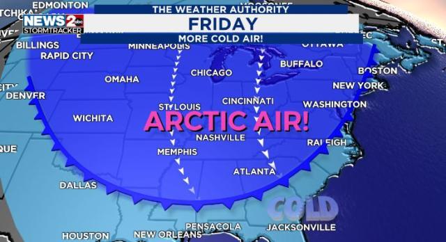
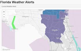
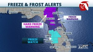
On Thursday morning, a total of fourteen counties across Florida were placed under a freeze warning as an intense wave of Arctic air swept through the state, causing a significant drop in temperatures.

According to a statement from the National Weather Service (NWS) in Tallahassee, shared on X (formerly known as Twitter), colder air began moving into the region early Thursday morning. The advisory warned residents to prepare for freezing temperatures and dangerous wind chills overnight. Forecasts indicated that temperatures could plummet into the 20s°F, with wind chill factors making it feel even colder—potentially dipping into the teens or low 20s°F.
The Florida Division of Emergency Management also noted that these temperatures are expected to remain below seasonal averages for this time of year. Residents across the affected counties were urged to take precautions, as the unusually cold conditions could pose risks to health, crops, pets, and infrastructure.
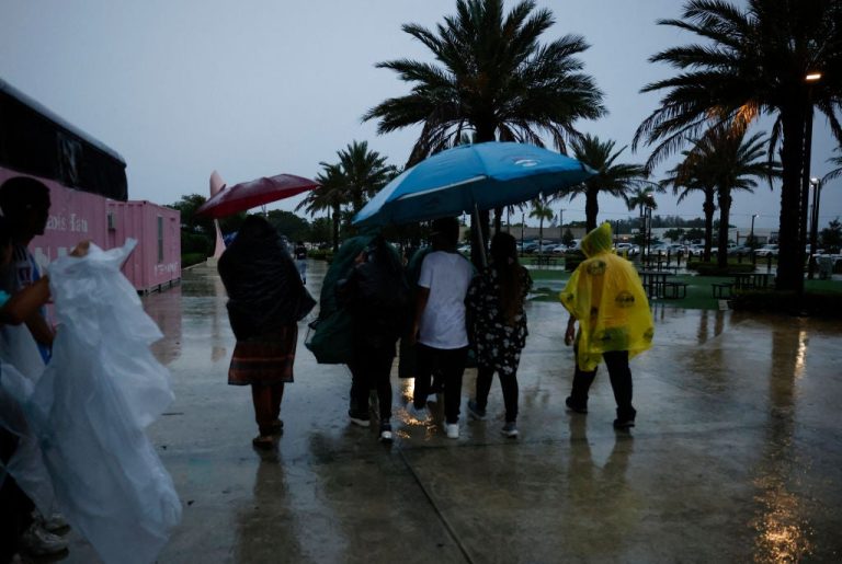
The ongoing cold snap has led several regions across Florida, stretching from Walton County to St. Augustine, to announce the opening of cold weather shelters. These facilities are being set up to provide warmth and safety for vulnerable residents, including the homeless and those without adequate heating in their homes, as temperatures continue to drop to dangerous levels.
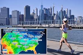
Meanwhile, in other parts of the United States, an extreme cold warning has been issued, spanning from North Dakota all the way down to South Texas. This broad region is bracing for severe winter conditions, with temperatures expected to plummet well below freezing.
In addition to the bitter cold, a winter storm is forecasted to bring significant snowfall across parts of the East Coast. According to AccuWeather, areas including Virginia, North Carolina, Maryland, and Delaware could see snow accumulations ranging from 6 to 12 inches by Thursday morning. Residents in these states are being urged to prepare for hazardous travel conditions, potential power outages, and disruptions caused by heavy snowfall and icy roads.
A freeze watch that was initially issued on Tuesday night for 13 counties across North and North Central Florida has since been upgraded to a freeze warning for 14 counties by Thursday morning. This escalation reflects the increasing severity of the cold weather conditions expected to impact the region.
The freeze warning will remain in effect until 9 a.m. on Friday, signaling the likelihood of dangerously low temperatures that could harm sensitive vegetation, damage outdoor plumbing, and pose health risks to vulnerable individuals.
The counties now under the freeze warning include:
• Alachua
• Baker
• Bradford
• Clay
• Columbia
• Duval
• Gilchrist
• Hamilton
• Levy
• Marion
• Nassau
• Putnam
• Suwannee
• Union
Residents across these areas are urged to take precautionary measures, such as covering plants, insulating exposed pipes, and ensuring that pets are brought indoors. Local authorities continue to monitor the situation and advise the public to stay updated on the latest weather alerts.
The Florida Division of Emergency Management has reported that below-average high temperatures for this time of year are expected to persist across the state. On Thursday, temperatures in the Florida Panhandle are forecasted to peak in the upper 50s to lower 60s°F, which is significantly cooler than the seasonal norm. In contrast, areas in Central and Southern Florida will experience comparatively milder conditions, with daytime highs ranging from the mid-70s to upper 70s°F.
During the night, temperatures are expected to drop sharply across North Florida, with lows forecasted to dip into the lower 30s to low 40s°F. Certain areas in the Panhandle could experience even colder conditions, with temperatures predicted to fall below freezing by Wednesday night, increasing the likelihood of frost and posing potential risks to crops, outdoor plumbing, and vulnerable residents.
The cold will feel even more intense due to wind chill effects. In the western Panhandle, feels-like temperatures could plummet into the upper teens to lower 20s°F. Meanwhile, the eastern Panhandle and areas extending into the western Big Bend are expected to experience wind chills ranging from the mid-20s to mid-30s°F by sunrise on Thursday morning. Residents are urged to take precautions by dressing warmly, protecting outdoor plants and plumbing, and ensuring pets have adequate shelter from the cold.
By Thursday night, sub-freezing temperatures are expected to spread across North Florida, with lows ranging from the mid-20s to mid-30s°F. Wind chill will make the cold even more intense, with feels-like temperatures falling into the mid to upper teens and low 20s°F throughout much of North Florida. In the southern Suwannee Valley, wind chills are expected to dip into the mid to upper 20s°F, while areas from the Nature Coast to regions north of the I-4 corridor will experience wind chills ranging from the low to mid-30s°F.
In Central Florida, temperatures on Wednesday night will drop to the upper 40s to upper 50s°F. By Thursday night, temperatures are forecasted to cool further, reaching lows in the upper 30s to mid-40s°F.
Meanwhile, South Florida will remain relatively warmer, with Wednesday night lows expected in the 60s to low 70s°F. However, by Thursday night, temperatures will fall into the upper 40s to upper 50s°F. Some areas in Southwest Florida may even see temperatures dipping into the low 50s°F.
When Will Florida Be Coldest?
According to the Florida Public Radio Emergency Network, the coldest temperatures across the state are expected on Friday morning. Here’s how the temperatures will vary:
• In the Florida Panhandle, lows could range from the upper 20s to low 30s°F, with some areas potentially experiencing freeze or frost conditions.
• For Central Florida, temperatures are forecasted to fall between the low to mid-40s°F, with colder readings likely in rural areas.
• In South Florida, lows will hover between the upper 50s and low 60s°F, although Southwest Florida could see temperatures dip into the low 50s°F.
This sudden drop in temperatures will be a stark contrast to the unusually warm conditions Florida had been experiencing, where highs were more consistent with typical April or May weather patterns.
Polk County Weather Forecast
While Polk County is not expected to experience freezing temperatures, it will still see a significant drop in temperatures. On Thursday night and Friday morning, lows could fall into the 30s°F, with wind chill values making it feel as cold as 33°F. By Friday night, temperatures are expected to range from the mid to upper 40s°F before warmer weather returns over the weekend. Overnight lows will rise into the 50s°F, with daytime highs reaching the 70s°F.
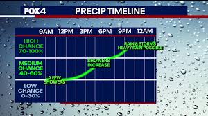
There’s also a slight chance of rain heading into the weekend and early next week. Below is the detailed forecast from the National Weather Service in Tampa:
• Thursday: Mostly cloudy skies, gradually clearing to become sunny, with a high near 67°F. Winds from the north-northwest at 8 to 10 mph.
• Thursday Night: Mostly clear skies, with a low around 39°F and winds from the north at 8 to 10 mph.
• Friday: Sunny with a high near 64°F. Wind chill could make it feel as low as 33°F in the morning. Winds from the northeast at 11 mph, with gusts up to 20 mph.
• Friday Night: Partly cloudy, with a low around 48°F. Winds from the north-northeast at 6 to 9 mph.
• Saturday: Partly sunny skies, with highs near 70°F. Winds from the east-northeast around 6 mph.
• Saturday Night: Mostly cloudy, with a low around 53°F and light northeast winds.
• Sunday: Partly sunny with a high of 73°F. Light north wind, increasing to 6 mph in the morning.
• Sunday Night: A 30% chance of showers, mostly cloudy, with a low around 54°F. Winds from the north-northwest at 3 to 5 mph.
• Monday: A 20% chance of showers before 1 p.m., followed by partly sunny skies and a high near 71°F. Winds from the north at 5 to 7 mph.
• Monday Night: Partly cloudy, with a low around 50°F.
• Tuesday: Clear and sunny, with a high near 74°F.
• Tuesday Night: Clear skies with lows around 50°F.
• Wednesday: Sunny and warmer, with highs reaching 77°F.
Overall, after a brief but intense cold snap, Polk County and much of Florida can expect a gradual return to milder temperatures by early next week.